
Ripensare tutto
Le storie, le interviste, i personaggi del nuovo numero di Rivista Studio.
330 attacchi da gennaio a novembre, quasi due al giorno: è il bottino di guerra americano per quanto riguarda le offensive guidate dai droni (ormai superfluo spiegare ancora cosa sono e come funzionano, ma se proprio volete approfondire qui c’è tutto quello che c’è da sapere) – e parliamo soltanto di Afghanistan. Aggiungeteci Pakistan, Yemen, Somalia, e i numeri si alzeranno ancora.
Delle principali controversie della guerra “robotica” comandata a distanza si è discusso molto e ancora si discuterà – guerra sublimata, guerra difficile da sentire come “reale”, guerra quasi astratta e virtuale – ma ora qualcosa sta cambiando: James Bridle (blogger trentunenne, uno degli esponenti di punta della nuova scena tecnologica londinese che avevamo incontrato e intervistato sul numero 9 di Studio) ha creato Dronestagram, un Tumblr in cui si porta la guerra su Instagram. Bridle si aggiorna riguardo gli attacchi di droni sul Bureau of Investigative Journalism, risale alla location esatta utilizzando Google Maps e “instagramma” lo scatto. Non mancano, come pop-up, le informazioni geografiche, temporali e statistiche su feriti e caduti. Non sempre Bridle è però in grado di scattare l’esatta coordinata dell’attacco, e alcune “location” devono per necessità di cose avere un’approssimazione di qualche chilometro. Per far diventare, come scrive lui stesso, la guerra astratta “un po’ più reale”.
La spiegazione dello stesso Bridle riguardo al suo progetto è la seguente:
Wadi al Abu Jabara. Beit al Ahan. Jaar. Dhamar. Al-Saeed. Tappi. Bulandkhel. Hurmuz. Khaider khel.
These are the names of places. They are towns, villages, junctions and roads. They are the names of places where people live and work, where there are families and schools. They are the names of places in Afghanistan and Yemen, which are linked by one thing: they have each been the location of drone strikes in the past couple of months. (The latest was in the early hours of November 7th, the night of the US election.)
They are the names of places most of us will never see. We do not know these landscapes and we cannot visit them.
What can reach them are drones, what can see them—if not entirely know them—are drones. At anywhere between five and fifty thousand feet, the drones are impervious to the weapons of the people below them, and all-seeing across the landscape. Drones are just the latest in a long line of military technologies augmenting the process of death-dealing, but they are among the most efficient, the most distancing, the most invisible. These qualities allow them to do what they do unseen, and create the context for secret, unaccountable, endless wars. Whether you think these killings are immoral or not, most of them are by any international standard illegal.
For a few weeks now, I have been posting images of the locations of drone strikes to the photo-sharing site Instagram as they occur (there’s more on the methodology below). Making these locations just a little bit more visible, a little closer. A little more real.


Come funziona Jigsaw, la divisione (poco conosciuta) di Google che sta cercando di mettere la potenza di calcolo digitale del motore di ricerca al servizio della democrazia, contro disinformazione, manipolazioni elettorali, radicalizzazioni e abusi.
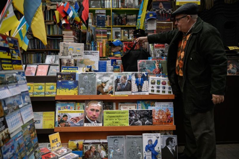
Reportage dalla "capitale del sud" dell'Ucraina, città in cui la guerra ha imposto un dibattito difficile e conflittuale sul passato del Paese, tra il desiderio di liberarsi dai segni dell'imperialismo russo e la paura di abbandonare così una parte della propria storia.